
Woodbridge Township Neighbors by Parcel
Public sources around a Woodbridge block are most useful when they are kept in order. The map gives adjacent parcel geography. The assessment search gives current assessment context and an owner or mailing contact for the selected parcel. BrowserView supplies the recorded document trail. Historic directories and newspapers can place a name at an address in a stated period. None of those records identifies every person in a home or proves a social relationship between neighbors.
| Source | What It Shows About a Block | Access |
|---|---|---|
| Woodbridge GIS Viewer | Adjacent parcel boundaries, map context, and block-lot clues | Public map navigation |
| Assessment search | Parcel, owner, mailing contact, and assessment context | Public current-assessment search |
| Middlesex BrowserView | Recorded parties, documents, dates, and legal descriptions | Public index; document coverage varies |
| Regional directories | Period name-and-address associations | State Library or library route |
| WPL newspapers and oral histories | Historical events, notices, and community context | Online collection or library help |
| Township Volunteer Directory | Published organization contacts serving the area | Township public page |
Owner, parcel, document party, and residence are different facts. A tax-mailing address may be a notification contact, not the owner’s home. A deed establishes a recorded transaction, not occupancy. The map is also not a survey or a measure of a legal boundary.
Note: Describe a result as an adjacent parcel or recorded owner fact, never as proof of who lives next door.
Map Woodbridge Township Neighbors Carefully
The official GIS viewer supports address or place search, parcel clicks, Layer List, Legend, Bookmarks, and Basemap controls. It has no configured public buffer, radius, measure, select, share, or locate tool. The supported method is simple map navigation: find the subject address, click the subject parcel, then click the surrounding parcel polygons one at a time. Note the PAMS PIN or block and lot, then move each selected parcel to the assessment record and, when needed, the Clerk’s document index.
- Enter the address or place in the GIS Viewer and identify the subject parcel polygon.
- Click surrounding parcel polygons and write down each block, lot, qualifier, or PAMS PIN shown in the map context.
- Search each selected parcel in the assessment interface. Keep the situs address, owner name, and mailing contact distinct.
- Use BrowserView only when a recorded title or document question remains. For a complete street trail, use the Woodbridge Township street records route.
The Woodbridge assessment search is the next step after a parcel is selected.
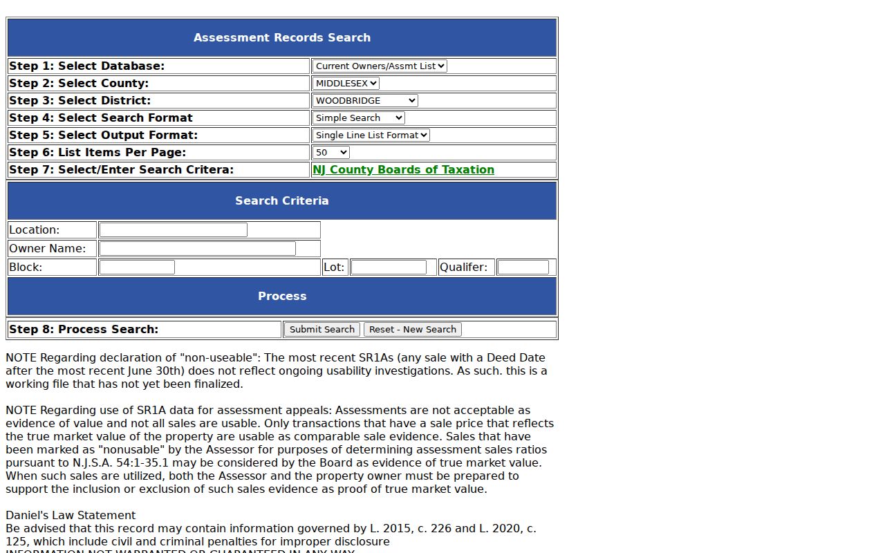
Its verified search fields are Property Location, Owner Name, Block, Lot, and Qualifier. The returned information is assessment context, not a current household list, and a displayed mailing address does not establish residence.
Woodbridge Township Neighbor Records Compared
The contrast is useful because three official sources answer different block questions. GIS establishes spatial adjacency. The assessment record connects the selected parcel to current assessment and owner-mailing data. A recorded deed names parties to a transaction and carries the legal description. No one source converts those facts into a neighborhood roster. The same caution applies to commercial neighbor-search categories: they may merge data of different dates and cannot substitute for an official parcel or recorded document.
| Source | Reliable block fact | Not established |
|---|---|---|
| GIS Viewer | Parcel geometry and surrounding parcel context | A household list or legal survey |
| Assessment record | Current tax parcel and owner-mailing context | Who currently occupies the parcel |
| Recorded deed | Transaction parties, date, and legal description | Social ties or current residence |
| Commercial listing category | A possible lead needing verification | Official proof or a complete block record |
The Middlesex BrowserView search is pictured below.
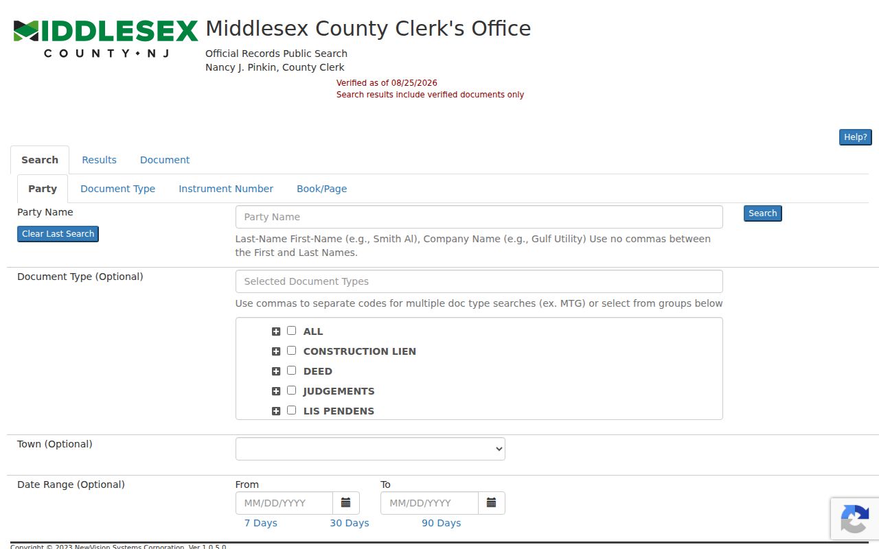
Search options include party name, town, date range, instrument number, book and page, lot and block, legal-description line, map number, and district or parcel information. A party search uses last name then first name without a comma. Read a document before treating an index line as conclusive.
Note: BrowserView’s stated online coverage differs by document type, and older material can require the County Clerk Registry or archive channels.
Woodbridge Township Neighbor Deed Parties
A recorded deed can help distinguish a parcel's documented ownership history from the people who may live nearby. In Middlesex BrowserView, use a party name, town, lot and block, legal-description line, date range, instrument number, or book and page to locate a record tied to the selected parcel. The index can show parties, document type, recording or received date, instrument number, consideration, municipality, and parcel identifiers. Open the document before relying on an index line.
For an earlier transaction, the deed's recital or being clause may point to a prior book and page or name the person from whom the grantor acquired title. Compare the same legal description and municipal context at each step. BrowserView's stated online coverage varies by document type, and older material may require the County Clerk Registry search room or the State Archives deed-microfilm route. A recorded party is not proof of a current neighbor or household member.
Voter Data for Woodbridge Township Neighbors
New Jersey provides an individual voter-status inquiry, not a block-voter tool. Its verified inputs are First Name, Last Name, County, and Date of Birth, with exact spelling rules. The portal may return a Voter ID for the person’s own status and ballot tracking. It does not authorize a map or list of registered voters near an address. A property owner may not be registered at the parcel, and a voter’s protected or mailing address can differ from assessment data.
Title 19 and OPRA-related election rules protect sensitive fields, signatures, and covered addresses. ACP participants and people protected by Daniel’s Law can have address restrictions. For a defined election record, use the appropriate Middlesex custodian and name the exact record sought and the permitted purpose. Do not use the individual tool to infer a block’s party choices, participation, or household makeup.
Historic research has a different path. Rutgers holds Woodbridge polling, lighting, and fire-district records from 1876 to 1928 as part of its 1668 to about 1930 township collection. Those materials can illuminate a period community layer after an appointment or research request, but they are not a modern neighbor directory.
Woodbridge Township Neighbor Contacts
Community contact is an opt-in, public layer. The Township’s Volunteer Directory helps residents find organizations that serve the area, including some that are not physically located in Woodbridge. It is not a membership or address list. The Township’s boards page identifies the Historic Preservation Commission, while the Historical Association offers a public museum and research-contact route. These sources can help someone reach a published organization without repackaging private participation information.
| Public contact route | How to use it | Limit |
|---|---|---|
| Woodbridge Volunteer Directory | Find a listed organization serving the township | Not a list of members or households |
| Historic Preservation Commission | Reach the Township’s published board route | Does not identify neighbors on a block |
| Historical Association of Woodbridge Township | Use the museum or public research contact | Not a private membership roster |
The Historical Association lists its museum at 86 Green Street, Woodbridge, with a public phone route at 732-634-1669 and Sunday hours of 1 to 4 p.m. Confirm visits and tours before going. The research record also identifies a P.O. Box 83 mailing route, so use the association’s current contact page when sending a request.
Historic Woodbridge Township Neighbors
A Woodbridge historical quirk is that community labels change across sources. Richmond directories for 1912 through 1918 listed Woodbridge, Port Reading, Fords, Keasbey, and Sewaren in a broader regional run; the 1919 through 1926 volumes list a different community set. An old address or surname may therefore appear under a community label that does not match a current mailing line. Preserve the printed locality and compare it with the legal description, block and lot, or historic map context.
The Township’s original boundaries included areas now associated with Carteret, Rahway, Edison, and Metuchen. An early Woodbridge result cannot be placed on a current block without comparing its date, source, locality, and legal description.
When an online search stops, use the full fallback chain. The County Clerk Registry search room or copy route handles land material outside BrowserView’s useful reach, and the State Archives holds county-deed microfilm through 1900. The Woodbridge Public Library Local History archive requires an appointment and its assistance form works best with a specific document, name, date, and location. State Library reels, library newspapers, Rutgers collections, and a narrow municipal OPRA request can each fill a different gap.
Woodbridge newspapers supply another dated check between directory years. The library’s online runs include the Independent Hour from 1876 to 1877, the Weekly Register from 1898 to 1902, the Woodbridge Independent from 1919 to 1939, the Fords Beacon from 1936 to 1960, and the Leader Press from 1967 to 1970, with some runs incomplete. Search a surname with the street and community name, then browse the page if OCR misses it. A historic notice can support period context, but it cannot verify a present neighbor.
Woodbridge Township Neighbor Lookup Limits
No Woodbridge government source found here provides a public roster of household members, utility customers, or delivery recipients by address. The GIS Viewer cannot supply a public buffer or radius result, and an adjacent parcel is not proof of a social neighbor. A multiunit property, a condominium qualifier, a business parcel, an owner mailing contact, or a protected address makes that distinction especially important.
The Address Confidentiality Program, N.J.S.A. 47:4-1 et seq., and Daniel’s Law, N.J.S.A. 47:1B-1 et seq., can lawfully restrict address visibility. Redactions also arise under record-specific rules. Ask the custodian why a field is withheld rather than attempting to work around it. A precise request for an identifiable government record can be made under OPRA, but the law does not require a custodian to create a private-person list.
Lawful personal use. Use Woodbridge Township neighbor information for a legitimate personal, historical, or civic question. Stalking and harassment are prohibited under N.J.S.A. 2C:12-10 and N.J.S.A. 2C:33-4 and 2C:33-4.1.
Note: For immediate safety concerns, contact emergency services or the appropriate public agency instead of investigating a person through records.