
Woodbridge Township ZIP Coverage
Woodbridge Township’s 2025 Department of Public Works report names ten core community-and-ZIP pairs. That municipal source is the right starting point for the postal directory. It does not draw USPS delivery polygons or settle an edge address. The post-office column therefore identifies only what the research confirms and sends every address-level question to USPS.
| Postal ZIP | Township Community | Post Office | Record-Search Note |
|---|---|---|---|
| 07001 | Avenel | Verify by address with USPS | Keep Avenel as a directory and newspaper term |
| 07067 | Colonia | Verify by address with USPS | Older material may use earlier area terms |
| 08863 | Fords | Verify by address with USPS | Selected directory and newspaper runs include Fords |
| 08861 | Hopelawn | Facility in Perth Amboy | Later Polk volumes list Hopelawn |
| 08830 | Iselin | Verify by address with USPS | Older sources can use Uniontown, Perrytown, or Graham Station |
| 08832 | Keasbey | Verify by address with USPS | Township DPW uses the Keasbey mailing label |
| 08840 | Menlo Park Terrace | Facility in Metuchen | Confirm the postal last line for a specific address |
| 07064 | Port Reading | Verify by address with USPS | Selected regional directories list Port Reading |
| 07077 | Sewaren | Verify by address with USPS | Listed across several selected directory volumes |
| 07095 | Woodbridge proper | Main post-office area | Does not represent every Township community |
The pairings matter because Woodbridge Township is not one postal town. A community label can be a precise extra search term when a record is not found under the broader Township name. Note: The official source supports the ten core pairs, not a claim that every ZIP boundary follows a Township line.
Woodbridge Township Postal Checks
The USPS postal lookup is the address-level authority for postal delivery information. It has separate address lookup, city/state lookup, and cities-by-ZIP modes. Use the complete street address when a mailing ZIP or postal city must be verified. Do not use a ZIP match to claim that someone resides in Woodbridge Township, owns the parcel, is registered there, or receives all mail at that location.
| USPS Mode | What to Enter | What It Verifies | What It Does Not Prove |
|---|---|---|---|
| Address lookup | Complete mailing address | Postal city and ZIP for that delivery address | Township residency or parcel ownership |
| City/state lookup | City and state | Postal ZIP choices associated with the entry | A municipal boundary |
| Cities by ZIP | ZIP | Postal city names associated with the ZIP | A household or voter roster |
Write down the returned street form, postal city, and ZIP before opening another record system. A postal correction can resolve a failed address search without changing the historic community name found in a directory or deed.
The Township source identifies community-and-ZIP pairs for municipal use, while USPS resolves delivery information for an actual address. They are complementary rather than competing sources. If a historic document uses a different locality, retain that printed wording too. Postal confirmation should refine the record search, not erase the period label that may lead to the correct directory, newspaper, or tax record.
Woodbridge Township Community Labels
The 08840 Menlo Park Terrace pairing is a useful Woodbridge Township postal quirk. The Township parcel layer includes Metuchen with 08840 on parcels inside Woodbridge, and USPS facilities for 08840 and 08861 are in Metuchen and Perth Amboy respectively. That information does not redraw a municipal boundary. It shows why an address needs an address-level postal check instead of a broad ZIP-map assumption.
Older names add another layer. Iselin may appear as Uniontown, Perrytown, or Graham Station, while historic records for the Township can refer to a territory that later became part of Carteret, Rahway, Edison, Metuchen, or another municipality. Save both the printed locality and the modern verified address or block-and-lot detail. This preserves evidence rather than forcing an old record into a current postal label.
Finding Woodbridge Township ZIP Records
A ZIP narrows postal geography, not a public property or resident database. The reviewed Woodbridge assessment screen has Property Location, Owner Name, Block, Lot, and Qualifier fields, but no verified ZIP field. The Woodbridge GIS Viewer and County Clerk index also did not expose a ZIP filter. A ZIP-wide property roster is therefore not something these records can promise.
- Verify the mailing address with USPS and retain its returned postal city and ZIP.
- Match that result to the Township community named in the municipal table, keeping the community as a historical search variant.
- Use Property Location in the Woodbridge assessment search to reach the parcel. Add block, lot, or qualifier if needed.
- Locate the parcel in the Woodbridge GIS Viewer and record map or tax-block context.
- Use lot/block, legal description, town, party, or date in the Middlesex County Clerk index for recorded-document history.
Once a ZIP has led to a particular street, the Woodbridge Township street directory gives the fuller address-by-address record chain. The state Voter Information Portal is an individual status route, not a ZIP browse tool.
Woodbridge Township ZIP Parcels
After postal verification, property research must switch keys. The situs address is the physical parcel location and belongs in assessment and GIS work. A tax-mailing address is correspondence information and can lawfully differ from the situs. The legal description, block, and lot connect land to the title and tax-map systems. This distinction protects against confusing a postal result with a property conclusion.
The Woodbridge Tax Assessor establishes assessment responsibility, while the county-linked search supplies address and parcel input fields. A live parcel card can contain additional assessment information, but the research did not confirm a result-column inventory. Quote a particular field only after viewing the current record. The tax record is neither a legal survey nor a household list.
The GIS parcel service also separates situs from owner-mailing fields. Its non-personal test demonstrated that a Woodbridge locality can have an out-of-state mailing contact. That is a practical reason to preserve both pieces of information without treating either one as proof that a named person occupies the parcel. Postal ZIP, mailing contact, and parcel location can each be valid but distinct facts.
The confirmed Woodbridge assessment-search inventory is limited to inputs, not a claimed parcel result. It includes:
- Property Location for a street or address search;
- Owner Name for an owner-to-parcel starting point;
- Block and Lot for local tax-map routing;
- Qualifier for condominium or related parcel distinctions; and
- output or list controls whose live labels can vary.
The Woodbridge assessment search is the point where a verified ZIP address becomes a Property Location or block-and-lot search.
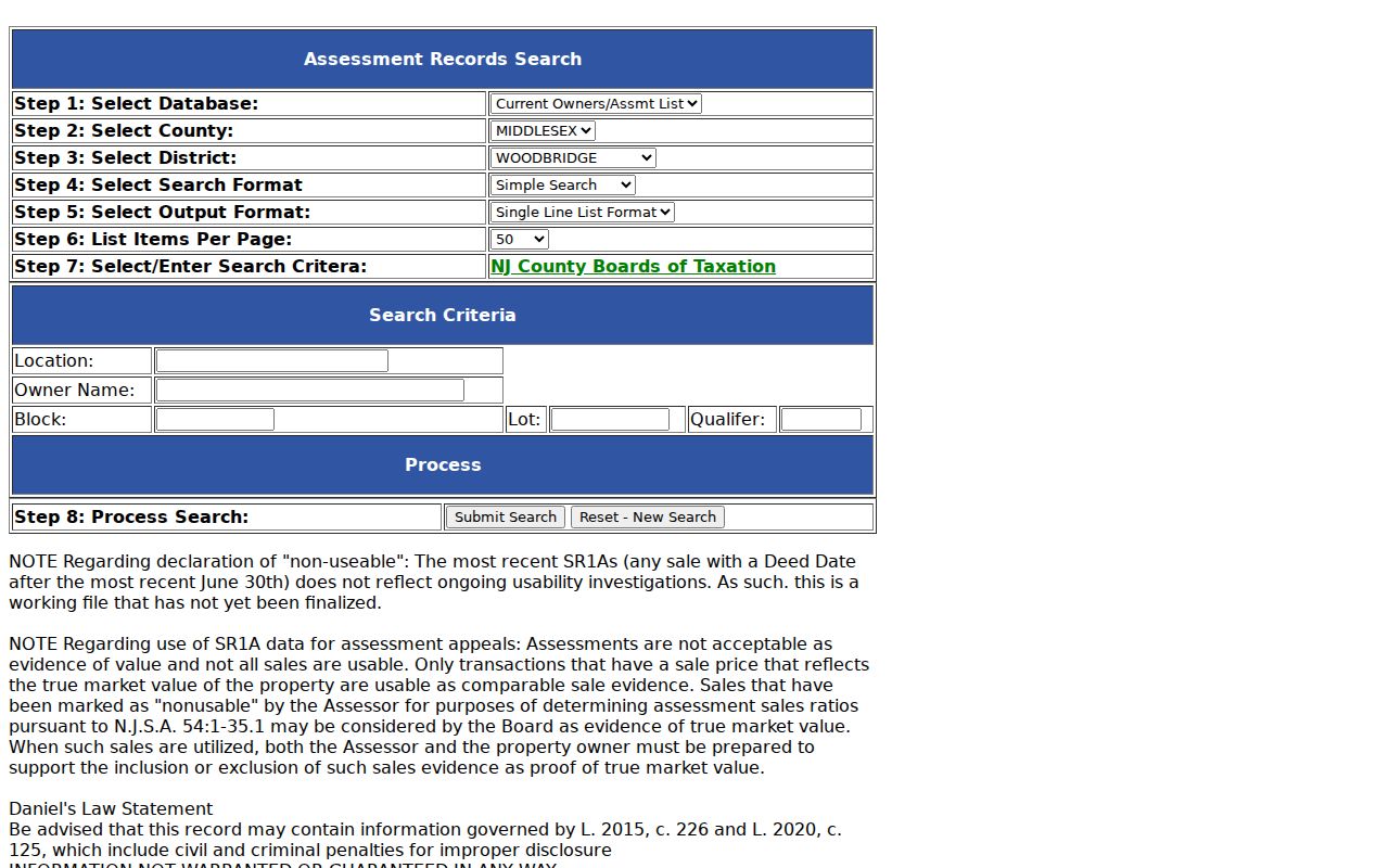
The portal’s visible fields show the shift from postal geography to the parcel identifiers needed for local property research. Note: No private parcel result was retained, and the live returned fields need direct verification.
Woodbridge Township ZIP Boundaries
A ZIP is a postal delivery geography, not a Township boundary, voting district, tax district, census geography, or neighborhood line. ZIP labels can cross municipal lines, and the same municipality can use several ZIPs. The municipal community table and an address-level USPS result can both be true while serving different purposes. Neither substitutes for parcel geometry or a legal boundary record.
- ZIP
- A postal routing code used with a delivery address.
- ZIP+4
- An additional delivery segment used with the base ZIP; it does not create a municipal district.
- PO-box ZIP
- A postal code assigned for post-office-box service, which is not evidence of a physical residence.
- Unique ZIP
- A ZIP used for a single organization or delivery arrangement where USPS assigns one.
- Carrier route
- A postal delivery route, not a municipal boundary or a public list of recipients.
For a boundary question, use the parcel map or official tax-map context. For a mailing question, use USPS. For a historic address, keep the source’s locality wording and compare the legal description. Those are separate Woodbridge Township ZIP code directory tasks.
Woodbridge Township ZIP Comparison
Postal, parcel, and title records can all show location information, yet they answer different questions. USPS confirms a delivery address and postal city. GIS shows map and parcel context. Assessment data supplies current tax-file identifiers. County Clerk records document a dated instrument and legal description. Comparing the source to the question prevents the most common ZIP code error: treating a postal label as evidence of current residence or ownership.
| Question | Best Woodbridge Township Source | Reason |
|---|---|---|
| What ZIP should this address use? | USPS ZIP Lookup | It verifies a specific postal delivery address |
| Which named community is associated with a core Township ZIP? | Township DPW report | It provides the ten community-and-ZIP pairs |
| Where is the parcel and its tax-block context? | Woodbridge GIS and assessment search | They use parcel geography and local identifiers |
| What recorded document concerns the parcel? | Middlesex BrowserView | It supports legal-description and party document research |
Woodbridge Township ZIP History
Historic Woodbridge was larger than the current Township and postal map. Township history describes an area whose later divisions help explain why an old directory, deed, or census may use a place name now outside Woodbridge Township. Regional directory inclusion also changes by year. A historic address is best preserved as printed, with its period community, then reconciled through legal description, block and lot, map context, and dated source evidence.
The State Library lists regional directory runs for 1912 through 1926, 1927, 1930, and selected later 1956, 1965, and 1967 volumes. Inclusion varies by community, so a ZIP code is not a substitute for checking the named localities in the particular book. For a gap between volumes, a historic newspaper or archival request can add a period-specific address lead.
The Woodbridge Public Library Local History and the New Jersey State Archives provide repository paths when local history predates a current parcel or postal label. Their material can add a period association, but it should not be converted into a claim about a modern delivery address.
Note: Postal verification and historic locality research should be saved as separate observations in a Woodbridge Township ZIP code search.
Woodbridge Township ZIP Limits
A ZIP result does not reveal a household, postal customer, owner, or voter list. It also cannot overcome address protections. The New Jersey Address Confidentiality Program and Daniel’s Law can restrict or alter public-facing address information for qualifying people. Missing data can be an intentional protection rather than a search failure.
Lawful use. Use Woodbridge Township ZIP code records for personal, lawful research, verify facts with the custodian, and never use postal or property information to stalk, harass, or harm another person.
For a controlled record request, identify the precise document and custodian rather than asking for a broad ZIP list. New Jersey confidentiality rules and record-specific exemptions remain in force even when the address has a familiar postal label.
If a result seems wrong, first recheck the address with USPS, then compare the parcel’s situs, block, lot, and legal description in the appropriate local record. A custodian can explain a record’s access route or redaction basis. That focused sequence is safer and more accurate than attempting to infer a person’s location from a ZIP code alone.